
TOPOGRAPHICAL SURVEYS
East Anglia · Hertfordshire · Essex · London · South East
Constructionline Gold | SSIP Accredited | Achilles | 17 PAYE Engineers
Surveys to OS datum · Trimble GNSS & X9 laser scanner · AutoCAD DWG delivered fast
CALL US ON: 01279 927 033


✅ Constructionline Gold ✅ SSIP Accredited ✅ Achilles Registered ✅ Trimble & Leica Equipment
✅ All Engineers PAYE — No Agency Workers ✅ £5m Public Liability & £5m Professional Indemnity
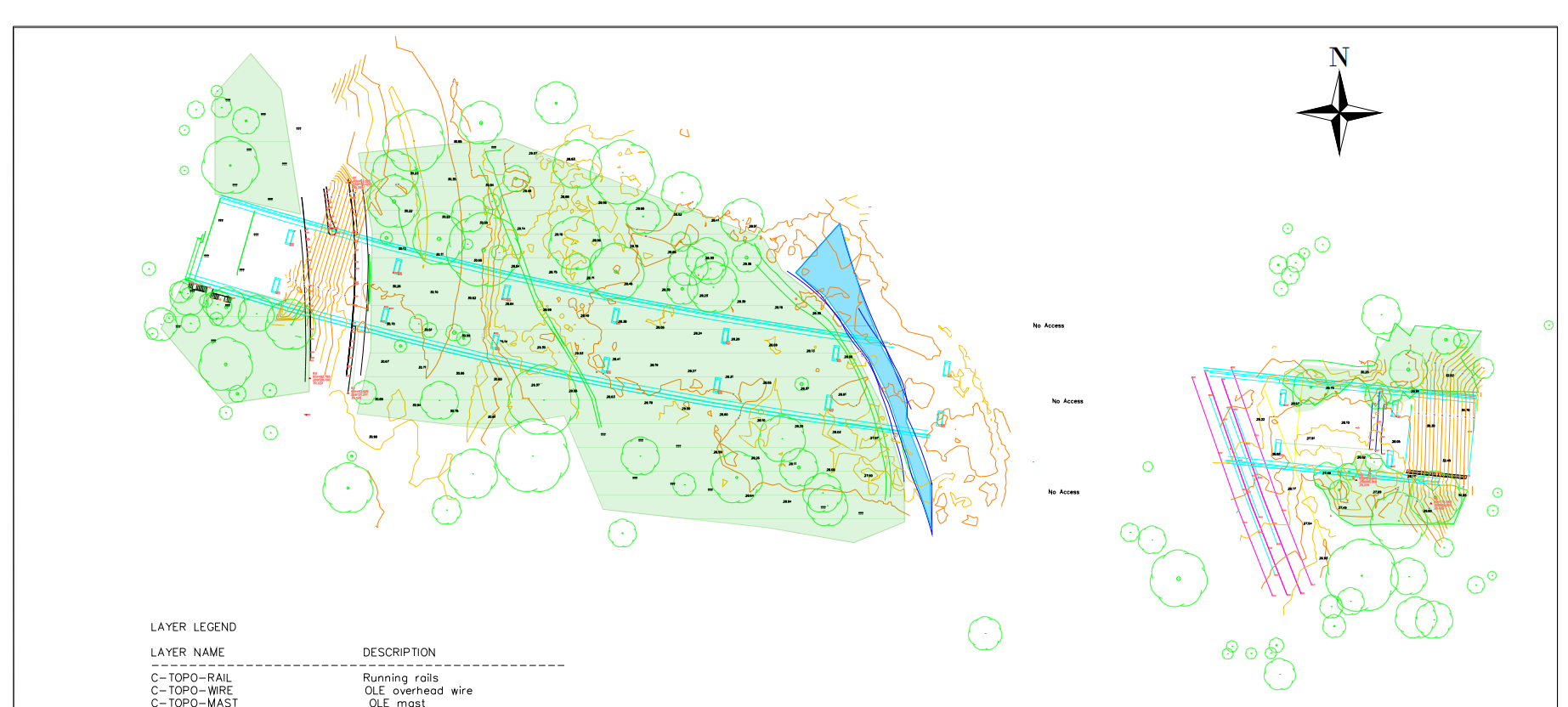
TOPOGRAPHICAL SURVEYS
AKN Engineering provides accurate topographic surveys to architects, structural engineers, developers and contractors across East Anglia, Hertfordshire, Essex, London and the wider South East. From a single residential plot to large commercial and infrastructure sites, our surveyors capture the data your design depends on.
Using Trimble GNSS, robotic total stations and — where dense detail is required — the Trimble X9 laser scanner, we record every relevant feature and level and deliver it as a clean, layered AutoCAD DWG referenced to Ordnance Survey datum.
We are not an agency. Every surveyor is directly employed by AKN Engineering, so you get consistent quality, clear accountability and a drawing you can design from with confidence.
DESIGNING FROM A SURVEY YOU CANT TRUST?
A topographic survey is the foundation of your whole design — and when it's wrong, everything built on it is wrong too.
You've all been there: levels that don't tie in, missing services, a sparse drawing that forces an RFI on day one, or a survey delivered in a format that fights your CAD. The redesign costs hours, and the errors don't surface until they're expensive to fix on site.
AKN Engineering surveys are different. We tie into Ordnance Survey datum (or your agreed site grid), capture the detail your discipline actually needs, and deliver a properly layered DWG that drops straight into your model.
Every AKN topographic survey gives you:
✅ Accurate levels and contours referenced to OS datum or site grid
✅ Full feature pick-up — boundaries, buildings, kerbs, trees, drainage and visible services
✅ Clean, layered AutoCAD DWG that imports without rework
✅ Optional 3D point cloud and terrain model for BIM workflows
✅ A clear survey extent and detail spec agreed before we mobilise
✅ Surveyors who understand what architects and structural engineers design fro
WHY CHOOSE AKN ENGINEERING
✅ Surveyed to Ordnance Survey Datum
Every survey is tied to OS datum or an agreed site grid, so your levels and coordinates are reliable and reproducible across the whole project team.
✅ Trimble GNSS, Total Stations & X9 Laser Scanner
We select the right instrument for the site — GNSS and robotic total stations for open ground, and the Trimble X9 laser scanner where dense, complex or hard-to-reach detail is required.
✅ Design-Ready AutoCAD Deliverables
Properly layered DWG drawings, PDF plans and 3D models built to import cleanly into your CAD or BIM environment — not a generic export
✅ Constructionline Gold, SSIP & Achilles Accredited
Full supply chain compliance for main contractors and developers, with £5m public liability and £5m professional indemnity insurance.
✅ Fast Mobilisation — Typically 48–72 Hours
When your design programme is tight, we get a surveyor on site quickly across our core coverage area.
✅ Regional Specialists — Not a National Call Centre
Deep knowledge of the East Anglia, Hertfordshire and Essex market. You speak to someone who knows your area.
SECTORS AND PROJECT TYPES
✅ Commercial buildings
✅ Highways & roads
✅ Industrial & logistics
✅ Residential development
✅ Rail & transport
✅ Civil engineering & infrastructure
✅ Data centres
✅ Energy & renewables
✅ Utilities & drainage.
✅ Education & healthcare
✅ Piling & groundworks
✅ Landscaping & environmental
OUR SERVICES
SETTING OUT SURVEYS
MEASURED BUILDING SURVEYS
AS-BUILT SURVEYS
TOPOGRAPHICAL SURVEYS
SITE ENGINEERING
PILING SETTING OUT
DESKTOP UTILITY SEARCH
VOLUME ANALYSIS
UNDERGROUND UTILITY SURVEYS
3D LASER SCANNING SURVEY
GPR SURVEYS
DRONE SURVEYS

LOCATIONS WE COVER
HERTFORDSHIRE
BEDFORDSHIRE
CAMBRIDGESHIRE
NORTHAMPTONSHIRE
LONDON
ESSEX
KENT
OXFORDSHIRE
BERKSHIRE
NORFOLK
SUFFOLK
LINCOLNSHIRE
RUTLAND
AKN Engineering is based in Bishop's Stortford, CM23, and covers the following regions as standard. Projects outside these areas considered — please call to discuss.
TRUSTED BY


Request a Quote
Ready to request a quote for a Topographical survey?
Fill out the form below, and you can expect to hear from us within 24 hours.
(If you do not receive a response within 24 hours (Mon-Fri) please email office@aknengineering.co.uk)
FAQs
-
A topographic survey is a measured land survey that records the position, level and shape of the natural and man-made features of a site — including ground levels, contours, boundaries, buildings, kerbs, trees, drainage, manholes and visible services. AKN Engineering captures this data with Trimble GNSS and robotic total stations and delivers it as a scaled 2D plan and 3D model to Ordnance Survey datum, giving architects and structural engineers an accurate base on which to design.
-
Cost depends mainly on site area, level of detail and access. As a guide, a small site survey typically starts from a few hundred pounds, rising with area, density of detail and any utility or 3D modelling requirements. AKN Engineering provides fixed-price quotes across East Anglia, Hertfordshire and Essex — call 01279 927 033 for a project-specific price.
-
Most domestic and small commercial sites are captured on site in a single day, with the drawing typically issued within a few working days. Larger or more detailed sites take longer; AKN Engineering confirms the survey and delivery programme at quotation stage.
-
Standard deliverables are a layered AutoCAD DWG drawing and a PDF plan, with levels and contours referenced to Ordnance Survey datum (or an agreed site grid). 3D point clouds, terrain models and additional formats are available on request.
-
A topographic survey measures the external site — ground levels, features, boundaries and services. A measured building survey records the building itself — floor plans, elevations, sections and internal detail. Many projects need both, and AKN Engineering can deliver them as a single coordinated package.
-
A 2D survey is a plan-based drawing — spot levels, contours, boundaries and site features delivered as a layered AutoCAD DWG with a PDF set, and it's all most design work needs. A 3D survey adds a georeferenced point cloud captured with the Trimble X9 laser scanner, which we turn into 3D terrain models and surface meshes for BIM coordination, earthworks and cut-and-fill analysis. You still get the 2D deliverables; the 3D model sits alongside them. We'll confirm which is right for your project at the quotation stage.
Get an Accurate Topographic Survey for Your Project
Contact AKN Engineering today to discuss your survey requirements. We'll confirm the survey extent, agree a fixed price and a delivery date, and mobilise quickly.
📞 Call: 01279 927 033
📧 Email: office@aknengineering.co.uk
📍 Based: Bishop's Stortford, Hertfordshire, CM23
🕐 Hours: Monday–Friday, 07:00–18:00
AKN Engineering Limited is a specialist site engineering and surveying company registered in England and Wales (Companies House No. 12237423), based in Bishop's Stortford, Hertfordshire. We provide topographic surveys, measured land surveys, contour surveys and 3D terrain models to architects, structural engineers, developers and main contractors across East Anglia, Hertfordshire, Essex, London, Kent, Cambridgeshire and the wider South East.
All surveys are tied to Ordnance Survey datum or an agreed site grid and delivered as layered AutoCAD DWG drawings, PDF plans and, where required, 3D point clouds and models. AKN Engineering holds Constructionline Gold accreditation, SSIP certification and Achilles registration, and carries £5m public liability and £5m professional indemnity insurance.
Also see: Site Engineering → | As-Built Surveys → | 3D Laser Scanning → | PAS 128 Utility Surveys →